Telluride and Black Canyon of the Gunnison Vacation Edition
About three times a year, Leti and I take a vacation from our jobs and hike ourselves all over creation. It's a great tradition. This fall we decided upon Telluride and Black Canyon of the Gunnison. We tried to go here in 2020, but the week we were supposed to go had rain in the forecast. Every. Single. Day. So, we scrapped those plans (because in 2020 you could scrap such plans and blame it on Covid) and went to the Sawtooth's. Well, we finally made it to Telluride. It turned out to be a grand adventure where we experienced fall and winter each day.
🥾🥾🥾🥾🥾

Sneffels High Line and Deep Creek Loop. Miles: 14. 3 Elevation gain: 3,986 ft. Date hiked: Oct. 13, 2022
We decided to do this trail at the last minute. The original trail, we noted, had snow on it, and we didn't have our winter spikes. (We ended up doing it the next day instead!). This trail was just lovely. We only got lost once (and saw person 1 of 3 on the trail). We started up the trail at what I thought was a steep incline. Leti thought it was relatively flat. We see the world very differently. We hiked through evergreens and aspens and then to a high meadow with a very serious rock garden.

What a view! Those small looking rocks were actually very large boulders. We walked through them to approach the saddle, which would be the high point (literally) of the hike.

Leti at the high point of the hike overlooking the next mountain range. On the other side of this mountain is a field of snow.

Here's the backside (north facing if you were wondering) of the mountain. Luckily, a crazy biker and some hikers had come before us. So, we could easily follow the trail down.
On the backside of the mountain, we decided upon a nice rock for a lunch spot. It really was lovely.
We lunched and then moved on as we had miles to go to get to the car. We passed several beautiful aspen groves. It was odd. Some of the aspen trees had already lost all of their leaves. Some were just turning. This was not related to location on the mountain. Odd.
On our way down, I took this lovely video. You could hear the leaves and the water. It is the sound of peacefulness. :)

The aspens were really radiant!
Our loop was more like a lollipop. Funny how light changes the trail. The last mile and first mile were the same. And yet, I didn't remember most of the first mile when I hiked it as the last mile. This may speak to my senility, but light really does change how a trail looks. Hike 1 in the books.
🥾🥾🥾🥾🥾

Bear Creek, Wasatch and Bridal Veil Trails Loop. Miles: 14.5. Elevation gain: 4,324 feet. Date hiked: Oct. 14, 2022
As previously mentioned, this hike was supposed to be hiked the day before, but we pulled off because of the threat of snow. As luck would have it, we started this hike the opposite direction than previously planned and because of that, we were able to hike the entire loop. Exciting happenings: we hiked through a lot of snow, we saw pretty waterfalls, and instead of seeing a bear, Leti was mistaken for a bear. Hahahaha! It really was hilarious. :)
We started this hike at the end of the road (literally). Telluride is a destination spot because you can't drive through Telluride to get to another city. There is this big mountain that prohibits that. So, we drove to the end of the road, donned our hiking gear, and headed up the mountain. There was a lot of water on this hike.
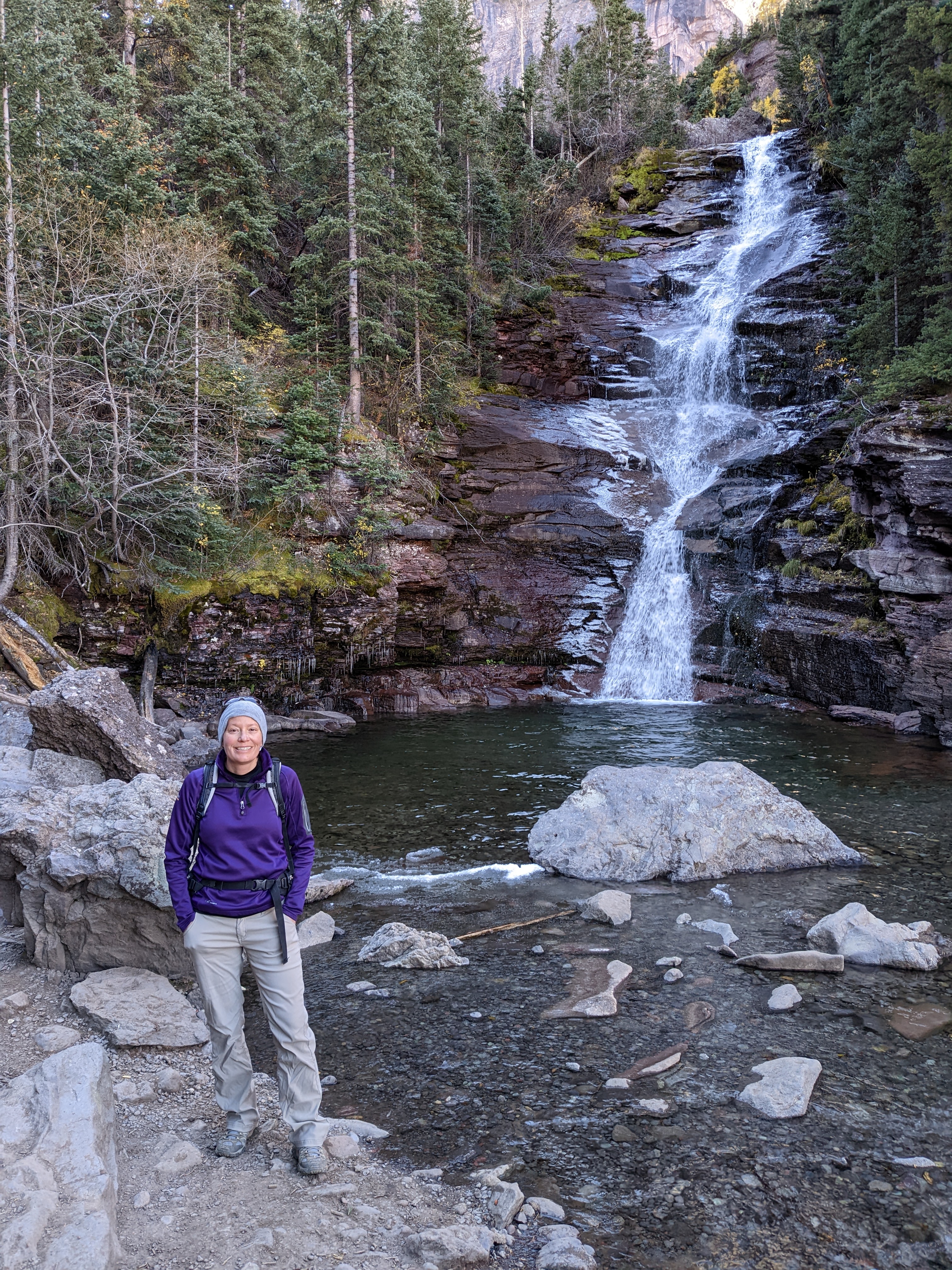
This is waterfall number one of many. This is also prior to the "bear sighting". Yes, it was that cold. There really was ice around the waterfall.
Leti and I kept hiking. A special feature of this hike is that you can drive to waterfall number three. Which is where the "bear sighting" occurred. Some lovely lady was with her husband taking pictures of the waterfall. I think they had driven to this part of the hike. Which is how we happened to take them by surprise. They thought they had the place to themselves, so when we approached rather quietly (I don't know how she missed my ragged breathing), she thought Leti was a stealthy bear out to get her. We apologized for scaring the living daylights out of her (she did jump, scream, and grab onto her husband's arm), and we carried on our way. I think I would have started coughing had I suspected that we were indeed in stealth mode.

Here is the waterfall where the "bear sighting" occurred. The waterfall is very pretty! At the top of the waterfall is a house. (Look on the cliff edge.) The hike goes behind this house, which is actually just a hydropower plant. Luckily, no one lives there. The hike up there every day would really get old fast.
At this point in the hike, I thought we would hit too much snow and turn around and come back. Leti thought we had a 60% chance of looping. I, of course, thought she had lost some marbles, but I kept that to myself, which was wise, because we did actually loop the hike. This hike, once we passed the hydroplant, was just vast. Most of the leaves were off the bushes and trees. It looked like winter had set in. We hiked and hiked and hiked up the mountain. It wasn't as steep as the day before because we went up the less steep side, which is actually quite unusual for us. Leti likes a challenge, and I like hiking with Leti, so we usually go up the steep side and come down the less steep side. I did sound like I had serious lung problems. Leti, on the other hand, breathed like a normal human as we traversed up the mountain side. We lunched about a mile and a half from the top. We wore our sunglasses because at this point, the snow was blinding.

The hills are not alive in this picture. They are under snow. This was not where "The Sound of Music" was filmed.
This is the saddle where we decided to go down the mountain on the other side. I can't decide if this was a well informed decision or not. There was a trail to follow. So, that was good. The problem was the amount of snow that we walked through. My feet got good and wet.
Once we decided to keep going, we tried to make haste down the mountain. We still had something like 7 miles to go. Haste in the snow was a bit tricky. I used my poles to keep me upright, which happened a lot.
It is hard to explain how vast 7 miles is. The ground we covered was so varied and so far down the mountain. It really was so beautiful and so much to take in.

This rather large rock cairn was a sure indicator that we were on the trail! Also, note the amount of snow in the background!

It is hard to detect that I am on the bridge, but I am on the bridge. Like I said, the vastness of this hike was hard to take in.
This trail ended on a bit of a bad note. The last two miles went through town! I get that Telluride is scenic, but it's definitely not a forest type trail. I do have to say, however, that my feet really liked the last two miles. It wasn't so rocky and there was exactly zero snow. We got back to the car. Two hikes down. One to go.
🥾🥾🥾🥾🥾

Gunnison Route. Miles: 1.8. Elevation loss: 1,800 feet. Date hiked: Oct. 15, 2022
You know it is going to be a good time if you have to get a permit to hike the trail. Which is what we had to do to hike the Gunnison Route. So, we got ourselves a permit (we were number 13 and 14 for the day. They only give out 15 permits per day.) and off we went. It was a rapid decline, kind of like my humor. 😁 We hit the trail feeling pretty good. It soon became apparent that this type of hike required the use of all limbs. There was even a chain that we used in one section of the trail because it is such a serious drop. But, in all honesty, from what the ranger said, I thought it was going to be a lot worse.

This is me with the 80 foot section of chain. This part was steeper.

The river from the river's edge. :)

Leti at the river's edge. It was while this photo was being snapped that a very brazen chipmunk was trying to sneak into our bags! Punk. Luckily, we were able to scare the little creature away and save our backpacks.

I took this photo. Look at that sky! Also, look at how high we had to climb to get out. I had some dread.
This is where a shady part of the hike happened, which I did not discover until later. There is a little campground down here along with a sketchy outhouse (no TP). I was in said outhouse while Leti, unbeknownst to me, took my hiking poles and put them in her backpack. This was to lighten my load. I thought my backpack was light, but I didn't check it. A big mistake. Anyway, this problem was not discovered until almost the top of the hike. Speaking of punks...
Well, we finished the hike in what would not be record time. I kind of sounded like I had a severe breathing problem most of the way up. Leti just bounded right up the mountain without really having any breathing problems. Humility is a good trait for me to develop. I digress. It really was a lovely hike. This was the end of our hiking vacation. Another great adventure in the books!


Comments
Post a Comment