Little Wildhorse to Bell, Ding and Dang, Fish and Owl Creek Loop, Natural Bridges, Gooseneck State Park, and Goblin Valley - all in one trip.
I think you could say that we like mucho hiking, even in remote places of the world. Or rather, Utah. Here is a post about our Spring Break Trip 2021. First, let's talk slot canyons. We started with Little Wildhorse on Day 1 and ended with Ding and Dang on Day 4. It was an adventure.
Little Wildhorse to Bell Canyon Stats: 8 mile loop with 787 feet elevation gain. Date hiked: March 30, 2021.
This was a beautiful little hike. The slots were not super tight, which was nice. And, very family friendly. I loved the texture on the walls.

Leti in the slot. Look at the walls. So beautifully textured.


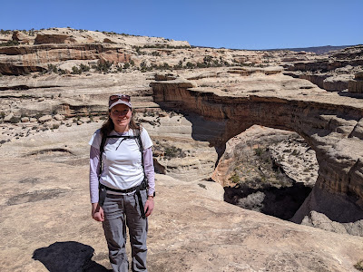
Me in Little Wildhorse. It's a beautiful area.
Coming down Bell Canyon, we didn't see a lot of people. It was very lovely. I highly recommend.
Ding and Dang Stats: 5.9 miles with 636 ft. elevation gain. Date hiked: April 2, 2021.
When we decided to hike this we thought we would only hike up Ding and down Ding. A nice lady told us that it was a very technical slot canyon. There would be 30 ft drops and water. Yikes! We saw a few more people and asked them about Dang. No 30 ft. drops. And there are ropes for the more technical parts. And the water was only waiste deep. Ding was very beautiful. Not terribly challenging. We walked over to Dang just to check out the drops. When we didn't see anything too bad, we just went for it. Dang had three sections where someone had tied a rope to help you get up or down depending on which direction you were going. It also had three pools of water. The first pool was indeed waiste deep. Leti could scale the rock walls above the water. I was not strong enough. So, I took off my shoes and socks, put them in my backpack, and went in. It wasn't so bad. Freezing, but not so bad. The other two pools were less deep. I was already wet, so not a big deal. Leti scaled the walls above the water with grace and ease. I walked through the pools. It pays to hit the weights. There was a big group in front of us, so we watched as they went above the water. It was every educational. There is a mile walk back to the car after going through the slots. That was perfect for me to dry off. I was completely dry by the time I got to the car. Overall, I would say it was a grand adventure.

Leti in Ding. It was a friendly slot canyon.

exactly zero pictures of her in Dang. And, she scaled walls over pools of water!

Another rope to the rescue!
Natural Bridges National Monument
Sipapu Bridge to Kachina Bridge Loop: 5.8 miles with 990 ft elevation gain. Date hiked: March 31, 2021
To get to this national monument, drive and drive and drive and drive. If you see very few cars on your way, you are probably headed in the right direction. Literally, this is in the middle of nowhere.
Once we arrived, it didn't take long to see our first natural bridge. We hiked down and down and down. And then we were about level with the bridges. And then we took some ladders to get under the bridges. It was a good adventure. We hiked across the canyon floor to the second natural bridge. From there, we decided we had enough of hiking on the canyon floor, so we looped back to the car. We could have gone for a few more miles on the canyon floor to the third bridge, but it just didn't seem worth it. All in all, it was just lovely.
Me with a rather spectacular looking natural bridge behind me.

Leti going down a ladder. One of the many. She looked like a pro!

Leti and me under the natural bridge. Good news, it didn't fall on us.
Owl Creek Fish Creek Loop
Owl Creek. We went about 1 mile before we had to turn around. We dropped a lot in elevation. :) Date hiked: March 31, 2021

Leti on the gigantic boulder in Owl Creek. This is the beginning of the descent.
This hike has a lot to it, and we only went on it for 1 mile! First, we ended up dropping into a canyon. That was really rather quite beautiful. As we were dropping down into the canyon, Leti noticed a kiva, a circular ceremonial place for the men of the pueblo people. It is extremely well preserved. This one was out of the wind and rain. So, we hiked over and took a look and took a few pictures. It was a very interesting piece of history.

Leti by the very intact kiva.
After the kiva, we continued to hike down. I think we made it to the canyon floor. It was a character building drop into the canyon. After about an hour, we headed back to the car. Overall, it was a grand adventure!
Gooseneck State Park

Leti with the goosenecks behind her. Which way is the water going?!
Honaker Trail. 4 miles. 1,643 elevation gain. Date hiked: April 1, 2021.
This was a fascintating little trail in Gooseneck State Park. To get to the trailhead, we passed several bovines who were out roaming on the range. Luckily, no bovines on the trail.
To start off, we kind of thought we were going to die dropping into the canyon. After we took the first step, we could see that the trail continued on without severe drop offs. Yay! It was a well defined little trail. From the rim, it look like it is impossible to go down to the river without ropes and climbing gear. But, amazingly, this trail required none of that. We hiked down to the river just in time to see the rafters we saw earlier in the day float on by. They said they were on the river for 10 days. I think they go 45 miles down the river from where we saw them. Forgive me for saying this, but that sounds just a tad too long for me. Painful. I think I could handle a few days on the water. And then, I am going to need to move on with my life.


Leti on the trail with the river behind her.
After we took some pictures and ate a snack, we headed back up the trail. It's odd to gain elevation at the end of the hike, but that is sort of how hiking goes in Southern Utah. We enjoyed going up as much as we enjoyed going down. It is just an interestin experience to scale a canyon wall.
Goblin Valley
Goblin's Lair. 2.4 miles. 219 ft. elevation gain. Date Hiked: April 2, 2021.
When it comes to places like Goblin Valley, I really can't think of any place like it. It really does look like a valley of goblins. The Goblin's Lair was less creepy than it sounds You drop into the lair and enjoy the nice, cool interior of shaded rock walls. Very little sun comes through. It's very nice. When we got to the lair, there was a group of people who had repelled in from an opening up top. That looked like a fun way to go. There was a little trail that you could crawl down that went deeper in the rock. I took a flashlight and crawled in for a bit. It was a unique little place, but I was happy to climb out again.

Leti in the lair. Ooooo. How scary.
After Goblin's Lair is Goblette's Lair. Her Lair was not quite as technical. I think a lot of people skipped it. But, both lairs were nice and cool, which was blessed because the outside temperature was in the 70s, which is quite toasty for this time of year. I liked Goblette's Lair a little better there were fewer people. After visiting the lairs, we enjoyed Goblin Valley. Lots of little Goblins everywhere. It's a one of a kind place to visit.

Me with some friendly goblins.


Looks like fun and very beautiful! I think that you and Aunt Leti should take a rafting trip sometime - even if it’s not 10 days long.
ReplyDelete